https://sputnikglobe.com/20240421/china-publishes-stunning-high-definition-geologic-atlas-of-the-moon-1118045668.html
China Publishes Stunning High-Definition Geologic Atlas of the Moon
China Publishes Stunning High-Definition Geologic Atlas of the Moon
Sputnik International
Humanity has been creating detailed maps of the Moon since the invention of telescopes in 17th century, with Polish astronomer Jan Hevelius credited with the first-ever atlas of the Earth satellite. The USSR advanced our knowledge of the Moon dramatically by snapping its far side with a probe in the 1950s. Now, China has taken up the mantle.
2024-04-21T19:05+0000
2024-04-21T19:05+0000
2024-04-21T19:12+0000
beyond politics
china
earth
ussr
science & tech
chinese academy of sciences (cas)
apollo
galileo
moon
atlas
https://cdn1.img.sputnikglobe.com/img/07e8/04/15/1118046007_139:0:1129:557_1920x0_80_0_0_82c73e4a3e8383649fa0afa3fae66cf5.png
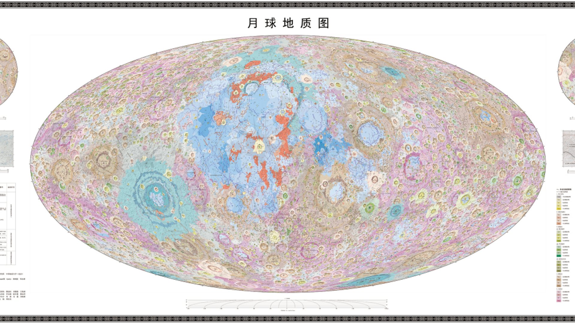
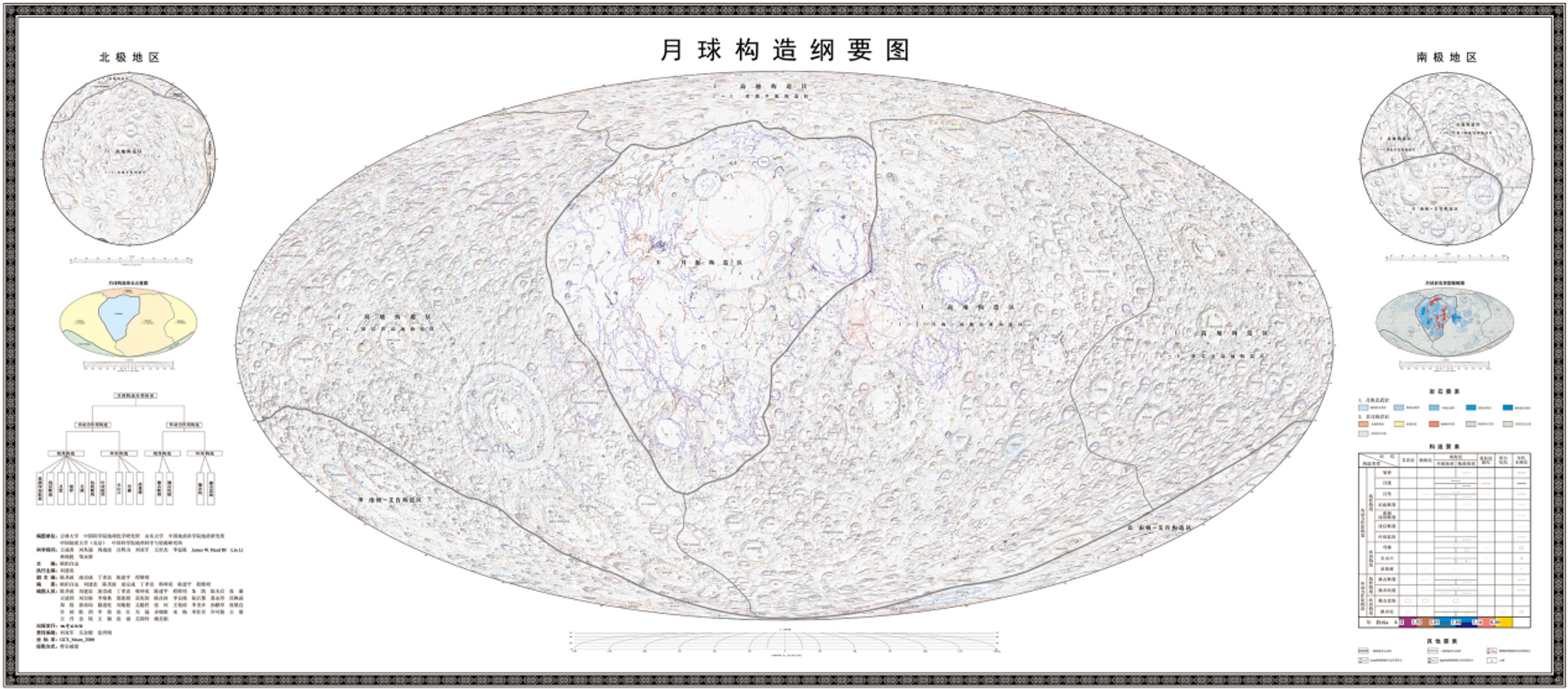
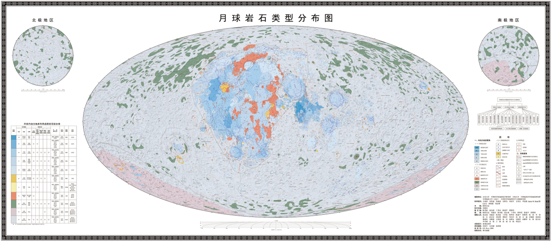
Chinese astronomers took one giant leap toward helping us get to know our closest celestial neighbor better on Sunday, publishing the world’s first high-definition geographic atlas of the Moon in 1:2.5 million scale.The atlas, compiled on the basis of research collected over the course of international and Chinese Moon missions, including China’s ambitious Chang’e lunar exploration program, includes a series of maps, from a geologic map of the lunar surface, to maps showing the distribution of lunar rock types, a map of the Moon’s tectonic plates, and more.Dr. Ouyang and a team of Chinese astronomers, geologists and cartographers first set to work compiling the detailed atlas in 2012, with the document promising to provide the Chinese lunar program with the scientific data it needs for additional unmanned exploration, and the PRC’s plans to put human beings on the Moon by 2030.Along with mapping the Moon, researchers developed a new lunar geological time scale feature showing the Earth satellite’s evolution over time.“Our map can provide a macroscopic geologic background to improve the purpose and efficiency of the sample research,” said Liu Jianzhong, a senior researcher from the Chinese Academy of Sciences’ Institute of Geochemistry, referencing China’s upcoming Chang’e-6 unmanned sample-collecting probe mission.Humanity’s effort to map the Moon can be traced back to the Sumerians and the Ancient Greeks, who created rough maps of the celestial body based on what could be observed using the naked eye. The first telescopic sketches of the Moon were published by the great Italian physicist and astronomer Galileo, German astronomer Simon Marius and Englishman Thomas Harriot. As telescopes improved, so too did astronomers’ fascination with mapping the Moon in detail, with 17th century Polish astronomer Jan Hevelius creating the world’s first detailed atlas of the Earth satellite, known as the Selenographia, in 1647. The atlas included not only its visible features, but maps and diagrams of the Moon’s various phases.The Moon became the first subject of astrophotography in the mid-19th century with the invention of the photo camera.100 years later, in 1959, the USSR’s Luna 3 space probe snapped the dark side of the Moon, allowing for the creation of the first-ever maps of the side of the lunar surface humanity had never seen before. Mapping improved with advances in technology, and in 1967, the first complete map of the Moon was published in the USSR in 1:1,000,000 scale, featuring geographic, geologic, and other features.From the late 1960s to the early 1970s, the US Apollo missions further advanced our knowledge of the Moon, sending back super-detailed photographs and videos both from the surface and from orbiters. Further Soviet robotic probes, including orbiters, soft landers and rovers, provided additional information.In 2016, China made history by landing its Chang’e 4 robotic spacecraft on the Moon’s far side.
https://sputnikglobe.com/20240207/our-shrinking-moon-could-be-a-problem-scientists-warn--1116630773.html
https://sputnikglobe.com/20240123/china-has-no-iintention-of-participating-in-space-race-imagined-by-us-1116332247.html
china
earth
ussr
Sputnik International
feedback@sputniknews.com
+74956456601
MIA „Rosiya Segodnya“
2024
News
en_EN
Sputnik International
feedback@sputniknews.com
+74956456601
MIA „Rosiya Segodnya“
Sputnik International
feedback@sputniknews.com
+74956456601
MIA „Rosiya Segodnya“
when will china go to the moon, what does the moon look like in atlas form
when will china go to the moon, what does the moon look like in atlas form
China Publishes Stunning High-Definition Geologic Atlas of the Moon
19:05 GMT 21.04.2024 (Updated: 19:12 GMT 21.04.2024) Humanity has been creating detailed maps of the Moon since the invention of telescopes in 17th century, with Polish astronomer Jan Hevelius credited with the first-ever atlas of the Earth satellite. The USSR advanced our knowledge of the Moon dramatically by snapping its far side with a probe in the 1950s. Now, China has taken up the mantle.
Chinese astronomers took one giant leap toward helping us get to know our closest celestial neighbor better on Sunday,
publishing the world’s first high-definition geographic atlas of the Moon in 1:2.5 million scale.
The atlas, compiled on the basis of research collected over the course of international and Chinese Moon missions, including China’s ambitious Chang’e lunar exploration program, includes a series of maps, from a geologic map of the lunar surface, to maps showing the distribution of lunar rock types, a map of the Moon’s tectonic plates, and more.
“The geologic atlas of the Moon is of great significance for studying the evolution of the Moon, selecting the site for [a] future lunar research station and utilizing lunar resources,” veteran Chinese Academy of Sciences lunar scientist Ouyang Ziyuan
said of the new resource. “It can also help us better understand the Earth and other planets in the Solar System, such as Mars,” the scholar added.
Dr. Ouyang and a team of Chinese astronomers, geologists and cartographers first set to work compiling the detailed atlas in 2012, with the document promising to provide the Chinese lunar program with the scientific data it needs for additional unmanned exploration, and the PRC’s plans to put human beings on the Moon by 2030.
Along with mapping the Moon, researchers developed a new lunar geological time scale feature showing the Earth satellite’s evolution over time.
The exhaustive atlas maps some 12,341 major impact craters, 81 impact basins, 17 types of lithologies (descriptions of the physical characteristics of rock formations) and 14 types of Moon structures.
“Our map can provide a macroscopic geologic background to improve the purpose and efficiency of the sample research,” said Liu Jianzhong, a senior researcher from the Chinese Academy of Sciences’ Institute of Geochemistry, referencing China’s upcoming Chang’e-6 unmanned sample-collecting probe mission.
Humanity’s effort to map the Moon can be traced back to the Sumerians and the Ancient Greeks, who created rough maps of the celestial body based on what could be observed using the naked eye. The first telescopic sketches of the Moon were published by the great Italian physicist and astronomer Galileo, German astronomer Simon Marius and Englishman Thomas Harriot. As telescopes improved, so too did astronomers’ fascination with mapping the Moon in detail, with 17th century Polish astronomer Jan Hevelius creating the world’s
first detailed atlas of the Earth satellite, known as the Selenographia, in 1647. The atlas included not only its visible features, but maps and diagrams of the Moon’s various phases.
The Moon became the first subject of astrophotography in the mid-19th century with the invention of the photo camera.
100 years later, in 1959, the USSR’s Luna 3 space probe snapped the dark side of the Moon, allowing for the creation of the first-ever maps of the side of the lunar surface humanity had never seen before. Mapping improved with advances in technology, and
in 1967, the first complete map of the Moon was published in the USSR in 1:1,000,000 scale, featuring geographic, geologic, and other features.
From the late 1960s to the early 1970s, the US Apollo missions further advanced our knowledge of the Moon, sending back super-detailed photographs and videos both from the surface and from orbiters. Further Soviet robotic probes, including orbiters, soft landers and rovers, provided additional information.
In 2016, China made history by landing its Chang’e 4 robotic spacecraft on the Moon’s far side.
